OUTER BANKS ROAD TRIP
Outer Banks Day Drive: Kitty Hawk to Pea Island
Most people come to the Outer Banks and spend the whole trip within a mile of their rental. That’s fine. But if you have one day to actually see what this barrier island is made of, this is the drive.
The northern OBX is a narrow strip of sand with more packed into it than most visitors ever bother to find. A dune the size of a small mountain. The field where powered flight happened for the first time. A waterfront town sitting on top of one of the great unsolved mysteries in American history. A lighthouse worth the climb. A wildlife refuge sitting in the middle of one of the most important bird migration corridors on the continent.
All of it connected by one road. All of it doable in a day if you start early and move with intention.
This guide takes you from Kitty Hawk south to Pea Island — the best stops, the right order, what to skip, and what not to miss. Use it as a day trip or as the blueprint for your first few days if you’re staying longer.
Outer Banks Day Drive at a Glance
- Drive time: 8 to 10 hours with stops — plan a full day, not a half day
- Start: Kitty Hawk or Kill Devil Hills — stock up on food and fuel before you head south
- End: Pea Island National Wildlife Refuge — the drive gets quieter and wilder the further south you go
- Best for: first-time OBX visitors who want the highlights in one day, or longer-stay visitors mapping out their first few days
- Skip it if: you want a slow beach day with no schedule — this is a moving trip, not a sit-on-the-sand trip
- Must-do stops: Jockey’s Ridge, Manteo waterfront, Bodie Island Lighthouse, Oregon Inlet, Pea Island
- Good to know: services get limited south of Nags Head — fuel up and pack food before you cross Oregon Inlet
START HERE
Outer Banks Day Drive Stops, Starting in Kitty Hawk
Kitty Hawk is where most visitors cross onto the Outer Banks — over the Wright Memorial Bridge and into a string of beach towns that runs south for seventy miles.
The town itself is functional. Grocery stores, gas stations, beach shops, the chain restaurants you’d find anywhere. If you need to stock up before the drive, this is the place. Once you push south into Kill Devil Hills and Nags Head, the options thin out.
The beach access here is worth a stop even if you’re not staying. Pull over, walk out, and get a read on the conditions. The Atlantic on the OBX runs colder than most visitors expect — the wind usually has something to say — and that combination sets the tone for the rest of the day.
Before you leave Kitty Hawk
Brew Thru is a drive-through convenience store where you pull your car inside the building to load up. Cold drinks, snacks, beach supplies. Exactly as useful as it sounds.
First move south
Head down US-158 or the Beach Road (NC-12). Kill Devil Hills starts immediately — Wright Brothers National Memorial is about three miles from the bridge.
Wright Brothers National Memorial
Technically in Kill Devil Hills, not Kitty Hawk — but the Wright Brothers used Kitty Hawk as their base camp and the name stuck. The NPS site is about three miles south of the bridge and worth the stop even if you think you already know the story.
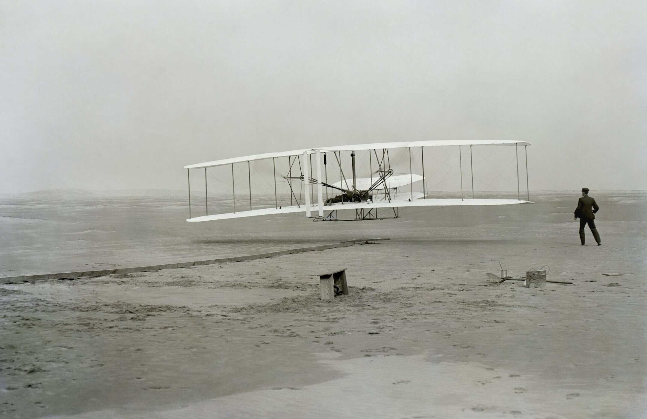
The Wright Brothers’ first powered flight, Kill Devil Hills, December 17, 1903. Public domain.
The granite monument sits on top of Big Kill Devil Hill — the launch dune, now grass-covered and stabilized. Below it, markers in the ground show where each of the four flights that morning ended.
The longest flight covered 852 feet and lasted 59 seconds. Walk the distance.
It feels short. That’s the point. The wind was gusting. The sand was December cold. Every attempt meant carrying a 600-pound aircraft back uphill on foot. The launch dune stood roughly ninety feet. None of that registers until you’re standing on it.
The visitor center has the full history — original engine parts, photos, reconstructed Flyer — and it’s well done. Give it 20 minutes before you walk the grounds.
Time needed
45 minutes to 1 hour covers the visitor center and the flight line walk. Add time if you have kids or history people in the car.
Best for
First-time OBX visitors, families, aviation and history fans. Not a skip-it stop.
Entry
America the Beautiful pass accepted. Otherwise there’s a current entrance fee at the gate — check the NPS site before you go.
Location
1000 North Croatan Hwy, Kill Devil Hills — right on US-158, easy in and out.
MAIN HUB
Nags Head: The Heart of the Northern Banks
Nags Head is where the northern Outer Banks concentrates. Restaurants, surf shops, outfitters, beach access, grocery stores — if you need something before the road gets quieter south of here, this is where you find it.
It works as a base camp for a longer trip or a lunch stop on a day drive. Either way, plan to spend real time here before continuing toward Bodie Island and Oregon Inlet.
Jockey’s Ridge State Park
Jockey’s Ridge is the largest active sand dune system on the East Coast. The main dune typically runs between 80 and 100 feet depending on the year — it shifts with the wind, and not in a small way. Thousands of tons of sand move here annually. The park looks meaningfully different from visit to visit.
The climb is short but the soft sand slows you down more than it looks like it should. From the top you can see the Atlantic on one side and Roanoke Sound on the other — the full narrow width of the Outer Banks laid out at once. On a clear day it’s one of the better views on the drive.
Hang gliders use the dune in the afternoons, launching off the crest with instruction from Kit
NATIONAL SEASHORE BEGINS
Back Across the Sound: Bodie Island and Oregon Inlet
Head back east across the causeway and turn south on NC-12. Within a few miles the landscape shifts — less development, more open dune, more sky. You’re inside Cape Hatteras National Seashore now and the drive starts to feel like a different place entirely.
Bodie Island Lighthouse

Bodie Island Lighthouse, Cape Hatteras National Seashore. Image credit: National Park Service.
Bodie Island Lighthouse stands 156 feet tall at the northern edge of the National Seashore, about four miles south of Nags Head. The horizontal black and white banding is distinctive — it’s one of the more photographed lighthouses on the coast, and earns it.
Climbs run seasonally and aren’t always available, so check the NPS site before you build your timing around it. The view from the top takes in sound, marsh, and Atlantic simultaneously. The grounds are worth the stop either way.
The marsh and pond around the base are serious birding territory. Herons, egrets, and waterfowl use the impoundment year-round — bring binoculars if you have them.
Fee
Free to walk the grounds. Lighthouse climb tickets are separate when climbs are running.
Time needed
45 minutes to 1.5 hours depending on whether you climb and how long you spend at the marsh.
Best for
Lighthouse photos, marsh birding, and the clearest visual signal that you’ve entered the National Seashore.
Climb schedule
Seasonal and limited. Check the NPS site before you go — it varies by week during shoulder season.
Oregon Inlet
About a mile south, Oregon Inlet cuts through the barrier island — the Atlantic on your left, Pamlico Sound on your right, moving water under the bridge in both directions. This is where the northern banks end and Hatteras Island begins.
Pull into Oregon Inlet Fishing Center on the north side of the bridge before you cross. It’s home to one of the largest charter fishing fleets on the East Coast, and if you time it right — boats typically start returning around 4 p.m. — you’ll see them coming back through the inlet with trophy flags flying from the outriggers.
The flags tell you what the boat found:
Blue flag
Blue marlin — caught or released.
White flag
White marlin — caught or released.
Yellow flag
Dolphin fish — the one you know as mahi-mahi.
Worth knowing
Most billfish at Oregon Inlet go back in the water. A flag means the boat found them — not that they came home.
The Fishing Center also has restrooms, a small shop, and somewhere to stretch before Pea Island. Watching the fleet return through the inlet is one of those OBX moments that stays with you whether you fish or not.
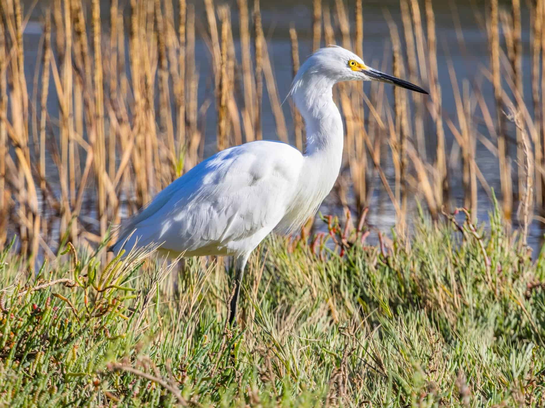
Pea Island National Wildlife Refuge, Hatteras Island. One of the top birding stops on the Atlantic Flyway.
FINAL STOP
Pea Island National Wildlife Refuge
Cross the bridge and you’re on Hatteras Island. The first thirteen miles south are Pea Island — no towns, no hotels, no campgrounds. Just marsh, dune, ocean, and sound managed by the U.S. Fish and Wildlife Service.
Pea Island sits directly in the Atlantic Flyway. More than 365 bird species have been recorded here, and the sound-side impoundments hold shallow water year-round — which means something is almost always moving through within easy sight of the trail.
North Pond Wildlife Trail
The North Pond Trail is the main stop — a flat loop with observation platforms along the water’s edge. You don’t need to walk the full loop. Get to the first platform, stop, and look slowly for twenty minutes. That’s usually enough.
Depending on season: great blue herons, snowy egrets, tundra swans, snow geese, peregrine falcons, yellowlegs, dowitchers, godwits. Fall migration peaks in October. Shorebirds start moving south from late July through September. Even in summer, the impoundments hold birds.
The visitor center near the north entrance has trail maps and a current species board. Stop there first if it’s open — it takes two minutes and tells you exactly where to look.
Fee
Free.
Time needed
45 minutes to 2 hours. The platforms are close to the parking area — even a short stop is worth it.
Bring
Binoculars, water, and sun protection. The trail is flat and exposed.
Best season
Fall migration peaks in October. Shorebirds move through July–September. Waterfowl in winter. Something’s here year-round.
Official Pea Island National Wildlife Refuge site
If you have more time, keep driving south — Hatteras Village and the ferry to Ocracoke are another hour down the island. Otherwise, Pea Island is a natural endpoint. Head back north before dinner and you’ll hit Nags Head in under an hour.
FINAL NOTE
Bottom Line
One day, one route, and you’ve covered the full range of what the northern Outer Banks actually is — not just the beach towns, but the history, the dunes, the working waterfront, the marsh, and the wildlife refuge at the end of the road.
Most people who do this drive once come back with a shorter list of where they want to spend more time. That’s the point. Use it as orientation. Then come back for the places that earned a longer stay.
Start early. The road south of Oregon Inlet gets quiet in ways that deserve more than a windshield view.
READ NEXT